

In 2014, Canada Post Corporation (CPC) issued definitive and commemorative featuring ten UNESCO (United Nations Educational, Scientific and Cultural Organization) World
Heritage sites of Canada. The World Heritage List, established in 1972, recognizes natural and cultural places of outstanding universal importance. To date, over 900 properties have been identified as having outstanding universal value, including:
- The Galapagos Islands, in Ecuador
- The Historic Sanctuary of Machu Picchu, in Peru
- Paris — the Banks of the Seine, in France
- The Acropolis, in Greece
- Stonehenge, in the United Kingdom
- The Great Barrier Reef, in Australia
There are 17 World Heritage sites located in Canada.

CPC selected the following World Heritage Sites for philatelic commemoration:
- Gros Morne National Park, Newfoundland
- Joggins Fossil Cliffs, Nova Scotia
- Landscape of Grand-Pré National Historic Site, Nova Scotia
- Old Town Lunenburg, Nova Scotia
- Miguasha National Park, Quebec
- Rideau Canal National Historic Site, Ontario
- Head-Smashed-In Buffalo Jump, Alberta
- SGang Gwaay, British Columbia
- Nahanni National Park, Northwest Territories
- Canadian Rocky Mountain Parks, Alberta and British Columbia
A. Domestic Definitives : March 31, 2014
Five "P" denominated definitives were issued on March 31, 2014, the first day of the 85 cent letter rate.


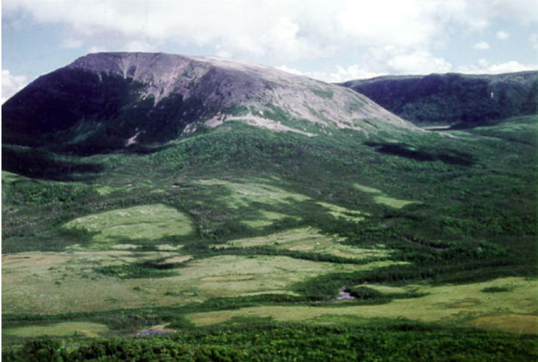
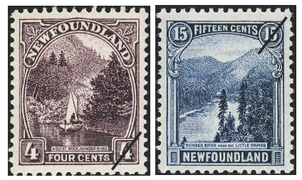
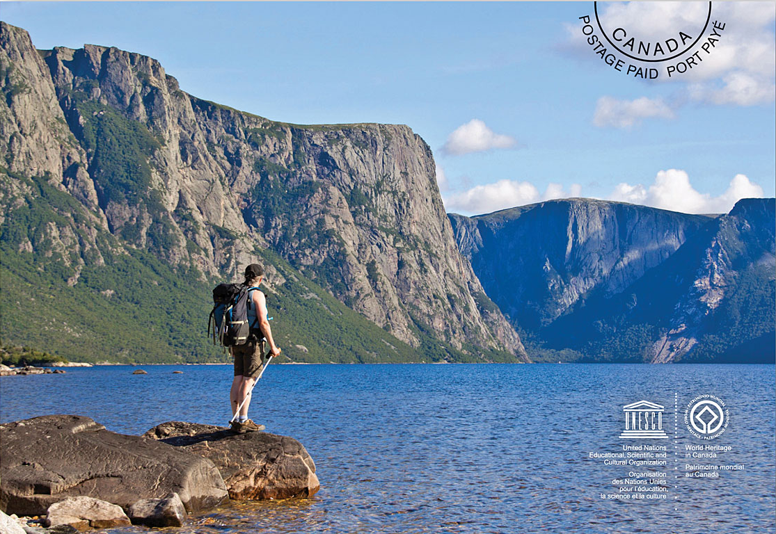
Gros Morne National Park, located on the west coast of Newfoundland, provides a rare example of the process of continental drift, where deep ocean crust and the rocks of the earth's mantle lie exposed. For that reason, Gros Morne National Park was declared a World Heritage Site in 1987.
Statement of Significance
Gros Morne National Park illustrates some of the world’s best examples of the process of plate tectonics. Within a relatively small area are classic, textbook examples of monumental earth-building and modifying forces that are unique in terms of their clarity, expression, and ease of access. The property presents the complete portrayal of the geological events that took place when the ancient continental margin of North America was modified by plate movement by emplacement of a large, relocated portion of oceanic crust and ocean floor sediments. The park also presents an outstanding demonstration of glaciation in an island setting. The fjords, waterfalls and geological structures of the park combine to produce a landscape of high scenic value. (UNESCO)
In 1923, Newfoundland issued definitive stamps featuring picturesque scenes of rivers which are now located in Gros Morne.
Canada Post, March 31, 2014
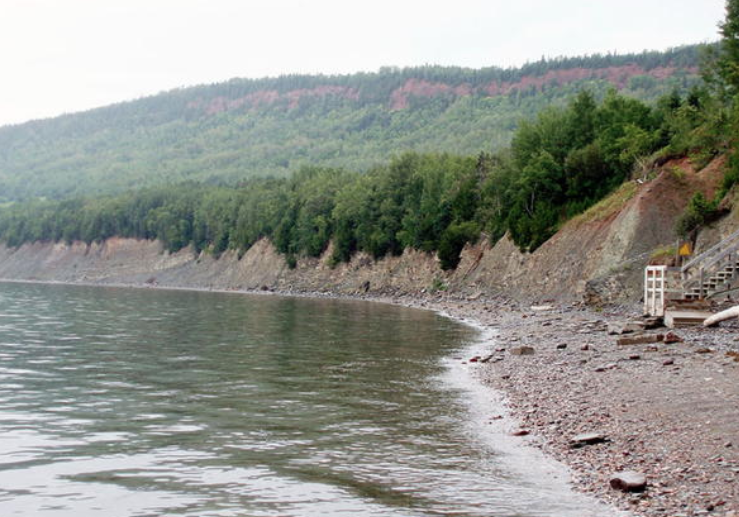
Joggins Fossil Cliffs (Nova Scotia)

The coastal section at Joggins, Nova Scotia, along the Bay of Fundy contains an unrivalled fossil record which represents the finest example in the world of the terrestrial tropical environment and ecosystems of the Pennsylvanian "Coal Age" of the Earth's history.
The UNESCO website provides this description:
The Joggins Fossil Cliffs, a 689 ha palaeontological site along the coast of Nova Scotia (eastern Canada), have been described as the “coal age Galápagos” due to their wealth of fossils from the Carboniferous period (354 to 290 million years ago). The rocks of this site are considered to be iconic for this period of the history of Earth and are the world’s thickest and most comprehensive record of the Pennsylvanian strata (dating back 318 to 303 million years) with the most complete known fossil record of terrestrial life from that time. These include the remains and tracks of very early animals and the rainforest in which they lived, left in situ, intact and undisturbed. With its 14.7 km of sea cliffs, low bluffs, rock platforms and beach, the site groups remains of three ecosystems: estuarine bay, floodplain rainforest and fire prone forested alluvial plain with freshwater pools. It offers the richest assemblage known of the fossil life in these three ecosystems with 96 genera and 148 species of fossils and 20 footprint groups. The site is listed as containing outstanding examples representing major stages in the history of Earth.
In 2013, Joggins Fossil Cliffs celebrated the 5th anniversary of being added to the UNESCO World Heritage Sites list. Bernard Pelletier's paintings of all of the Heritage Sites in Canada were on display at the Joggins Fossil Centre from July to September. His Joggins Fossil Cliffs canvas was unveiled on July 7, 2013.

Unveiling of Pelletier's painting of Joggins Fossil Cliffs, July 7, 1013
Don Trenhol, Carolyn Melanson,Elizabeth Kosters


Canada Post, March 31, 2014


Nahanni National Park (Northwest Territories)
The UNESCO web site explains the significance of Miguasha National Park:
Eusthenopteron foordiThe palaeontological site of Miguasha National Park, in south-eastern Quebec on the southern coast of the Gaspé peninsula, is considered to be the world's most outstanding illustration of the Devonian Period known as the 'Age of Fishes'. Dating from 370 million years ago, the Upper Devonian Escuminac Formation represented here contains five of the six fossil fish groups associated with this period. Its significance stems from the discovery there of the highest number and best-preserved fossil specimens of the lobe-finned fishes that gave rise to the first four-legged, air-breathing terrestrial vertebrates – the tetrapods.
Eusthenopteron foordi, nicknamed the "Prince of Miguasha", is the best known fossil at Miguasha and was featured on the 1991 Prehistoric Life in Canada stamp shown below.
Canada Post, March 31, 2014

Located along the South Nahanni River, one of the most spectacular wild rivers in North America, Nahanni National Park contains deep canyons and huge waterfalls, as well as a unique limestone cave system. The park is also home to animals of the boreal forest, such as wolves, grizzly bears and caribou. Dall's sheep and mountain goats are found in the park's alpine environment.
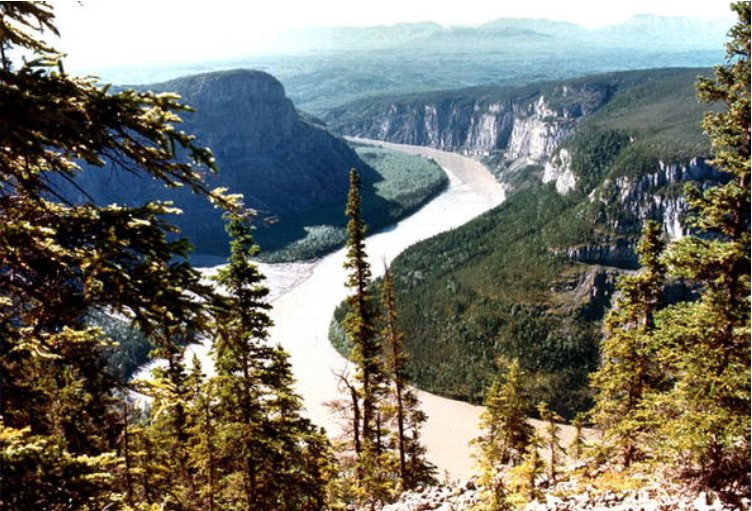
Nahanni was accepted as a World Heritage Site in 1978
Statement of Significance
Nahanni National Park is a 4,700 sq. km. undisturbed natural area of deep river canyons cutting through mountain ranges, with huge waterfalls and complex cave systems. The geomorphology of the park is outstanding in its wealth of form and complexity of evolution. Fluvial processes and features predominate. Within the park are examples of almost every distinct category of river or stream that is known along with one of North America’s huge waterfalls, Virginia Falls. The Flat and South Nahanni rivers are older than the mountains they dissect and have produced the finest examples of river canyons in the world, north of 60º. The injection of igneous rock through tectonic activity has resulted in spectacular granitic peaks. (UNESCO)

South Nahanni River stamp 1991
The South Nahanni River provides the focus for Nahanni National Park, offering an outstanding wilderness experience by canoe, kayak, raft or those on foot who wish to travel its shores. In 1991, the South Nahanni was pictured on a stamp issued to recognize the importance of great Canadian rivers.

Canada Post, 2014
Canadian Rocky Mountain Parks (Alberta and British Columbia)


Statement of Significance
Renowned for their scenic splendor, the Canadian Rocky Mountain Parks are comprised of Banff, Jasper, Kootenay and Yoho national parks and Mount Robson, Mount Assiniboine and Hamber provincial parks. Together, they exemplify the outstanding physical features of the Rocky Mountain Biogeographical Province. Classic illustrations of glacial geological processes — including icefields, remnant valley glaciers, canyons and exceptional examples of erosion and deposition — are found throughout the area. The Burgess Shale Cambrian and nearby Precambrian sites contain important information about the earth’s evolution. (UNESCO)

Banff National Park, $2.00 definitive stamp, 1985

Jasper National Park, 52 cents commemorative, 2007
Burgess Shale Formation Fossils
The
505 million-year old Burgess Shale Formation located in the Canadian
Rocky Mountain Parks is one of the world's earliest fossil beds
containing soft-part imprints of the middle Cambrian period. In 1990,
the fossil of the strange-looking soft invertebrate Opabian regalis was depicted on one of the Prehistoric Life in Canada stamps.


Opabina
is one of the oddest animals of the Burgess Shale fauna, having five
eyes and a long flexible proboscis tipped with grasping spines.

Canada Post, March 31, 2014
B. Commemoratives (U.S. and International Letter Rates) : May 16, 2014
 $1.20 denomination US Rate : Landscape of Grand-Pré, Lunenburg, Head-Smashed-In Buffalo Jump
$2.50 denomination International Rate : SGang Gwaay, Rideau Canal
$2.50 denomination International Rate : SGang Gwaay, Rideau Canal
Landscape of Grand-Pré (Nova Scotia)


Statement of Outstanding Universal Value
The Landscape of Grand Pré is an exceptional living agricultural landscape, claimed from the sea in the 17th century and still in use today applying the same technology and the same community-based management. Grand Pré is also the iconic place of remembrance of the Acadians who lived in harmony with the native Mi’Kmaq people before the Expulsion which began in 1755. Its memorial constructions form the centre of the symbolic re-appropriation of the land of their origins by the Acadians, in the 20th century, in a spirit of peace and cultural sharing with the local area community.In 1930, a view of Grand Pré was featured on the 50 cent definitve stamp.

View of Grand Pré, Nova Scotia the home of Evangeline, heroine of Longfellow's famous poem of that name. The view is a composite one, taken from photographs, and shows the museum, statue of Evangeline, and the ancient well, grouped together for pictorial effect. The grounds and buildings are maintained as a national shrine of Acadian relics.(Canadian Postal Archives)
The church Grand Pré was shown on the post card issued by Canada Post Office in 1972.


UNESCO post card 2014

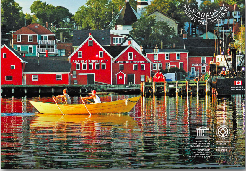
Old Town Lunenburg (Nova Scotia)


The UNESCO website provides this description of Lunenburg:
Lunenburg is the best surviving example of a planned British colonial settlement in North America. Established in 1753, it has retained its original layout and overall appearance, based on a rectangular grid pattern drawn up in the home country. The inhabitants have managed to safeguard the city's identity throughout the centuries by preserving the wooden architecture of the houses, some of which date from the 18th century.
Old Town Lunenburg is the best surviving example of a planned British colonial settlement in North America. Established in 1753, it has retained its original layout and overall appearance, based on a rectangular grid pattern drawn up in the home country. The inhabitants have safeguarded the town’s identity throughout the centuries by preserving the wooden architecture of the houses and public buildings, some of which date from the 18th century and which constitute an excellent example of a sustained vernacular architectural tradition. Its economic basis has traditionally been the offshore Atlantic fishery, the future of which is highly questionable at the present time.
In 2003, CPC issued a commemorative envelope to celebrate Lunenburg's 250th anniversary.

CPC issued a stamp in 1995 to commemorate the centennial of the Lunenburg Academy which "represents a
superb period of school construction in Nova Scotia, featuring
beautifully panelled white wood ceilings, floors and wainscotting of
birch, and the rest of the interior finish in ash and birch"


The Rideau Canal, a system of lakes, rivers and canals flowing 200 kilometres
from Ottawa to Kingston, was added to the World Heritage List in 2007.


Head-Smashed-In Buffalo Jump (Alberta)


Head-Smashed-In Buffalo Jump is an archaeological site located near Fort Macleod, Alberta, at a location where the foothills of the Rocky Mountains meet the Great Plains. The buffalo jump was used for 5,500 years by the indigenous peoples of the plains to kill buffalo by driving them off the 11 metre high cliff.
Statement of Significance


SGang Gwaay (British Columbia)

The village of Ninstints (Nans Dins) is located on a small island off the west coast of the Queen Charlotte Islands (Haida Gwaii). Remains of houses, together with carved mortuary and memorial poles, illustrate the Haida people's art and way of life. The site commemorates the living culture of the Haida people and their relationship to the land and sea, and offers a visual key to their oral traditions.

Statement of Significance

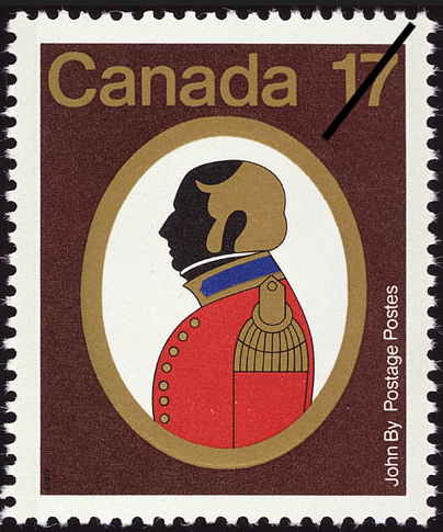
The Rideau Canal, a monumental early 19th-century construction covering 202 km of the Rideau and Cataraqui rivers from Ottawa south to Kingston Harbour on Lake Ontario, was built primarily for strategic military purposes at a time when Great Britain and the United States vied for control of the region. The site, one of the first canals to be designed specifically for steam-powered vessels, also features an ensemble of fortifications. It is the best-preserved example of a slackwater canal in North America, demonstrating the use of this European technology on a large scale. It is the only canal dating from the great North American canal-building era of the early 19th century to remain operational along its original line with most of its structures intact. (Source : UNESCO)
Stamps featuring the Rideau Canal were issued in 1998
The Rideau Canal was built between 1826 and 1832 under Colonel John By. Canada Post Office issued a commemorative stamp in 1979 to mark the bicentenary of his birth.
Head-Smashed-In Buffalo Jump (Alberta)
Head-Smashed-In Buffalo Jump is an archaeological site located near Fort Macleod, Alberta, at a location where the foothills of the Rocky Mountains meet the Great Plains. The buffalo jump was used for 5,500 years by the indigenous peoples of the plains to kill buffalo by driving them off the 11 metre high cliff.
Statement of Significance
The significance of the landscape of Head-Smashed-In Buffalo Jump lies in its cultural, archaeological, and scientific interest. The deep layers of bison bones buried below the cliff represent nearly 6000 years of use of the buffalo jump by Aboriginal people of the Northern Plains. This landscape is an outstanding illustration of subsistence hunting techniques that continued into the late 19th century and which still form part of the 'traditional knowledge base' of the Plains nations. It throws valuable light on the way of life and practices of traditional hunting cultures elsewhere in the world. (UNESCO)In 2002, Canada Post issued a set of 10 stamps to commemorate extraordinary tourist attractions. Head-Smashed-In Buffalo Jump was among the attractions aimed at international communities.
$1.25 international letter rate stamp issued in 2002
SGang Gwaay (British Columbia)
The village of Ninstints (Nans Dins) is located on a small island off the west coast of the Queen Charlotte Islands (Haida Gwaii). Remains of houses, together with carved mortuary and memorial poles, illustrate the Haida people's art and way of life. The site commemorates the living culture of the Haida people and their relationship to the land and sea, and offers a visual key to their oral traditions.
Memorial poles
Statement of Significance
At the village of SGang Gwaay llnagaay (Nan Sdins) the remains of large cedar long houses, together with a number of carved mortuary and memorial poles, illustrate the art and way of life of the Haida. The site commemorates the living culture of the Haida, based on fishing and hunting, their relationship with the land and sea, and offers a visual key to their oral traditions. The village was occupied until shortly after 1880. What survives is unique in the world, a 19th century Haida village where the ruins of houses and memorial or mortuary poles illustrate the power and artistry of Haida society. (UNESCO)The 2014 World Heritage Stamp series was the first time SGang Gwaay was featured on a Canadian postage stamp.